|
 |
|
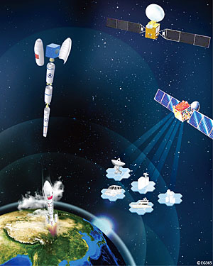
SPACE PLANS: A drawing of the Compass G2 navigation satellite network. The Compass G2 is the second satellite of the Beidou global navigation system (TI GONG) |
He said Beidou held significant advantages over global positioning system (GPS) navigation systems. In-car Beidou systems would be able to update traffic jams in real-time on the screen, which will also reveal the car's accurate location and traffic situation in the city. The surrounding areas will be marked with different colors on the screen to show differing degrees of congestion so the driver can choose the best route among all possible. Ran said if an area is marked red, the color signifying the worst traffic jams, the system suggests that the driver make a detour around the area. If Beidou navigators are installed in many cars throughout cities, drivers would be able to save time and energy while also reducing air pollution.
During the 2008 Summer Olympics, the Beidou system successfully provided traffic navigation services to alleviate congestion in Beijing.
Since Beidou was put into operation on December 15, 2003, the system has performed stably, with a reliability rate of 99.98 percent, according to a seminar at the end of 2008. The seminar marked the fifth anniversary of the Beidou's application and was organized by the China Satellite Navigation Application Administrative Center. It was also announced during the seminar that the system had provided 250 million individual location services, 120 million separate communication services and 25 million timing services. Seminar speakers also expected that registered users would increase from more than 40,000 at the end of 2008 to more than 100,000 in 2009 and 2010.
Several prototype applications have helped to stimulate commercial interest in the technology. These projects have covered a wide range of industries including water conservation, hydropower, fishing, transportation, weather forecasting, mapping, geological surveying, disaster relief, tourism, public security and national defense. These projects have also prompted development in the related electronics, telecommunications, machinery manufacturing and geographic information industries. The system has seen enormous economic profit. "In the near future, the system will start to provide its navigation and other services to foreign users," said Zhao.
The Beidou 1 is a regional navigation system. Its terminals need ground stations to communicate with satellites to obtain location information. Experts said the regional navigation system is very vulnerable to electromagnetic interference during wars. After China completes and launches all the satellites needed to make Beidou an operational global positioning system in 2020, it will comprise a constellation of dozens of satellites, similar to the scale of the technology involved in GPS.
The positioning function of Beidou 2 will be accurate within a few centimeters. It will inherit all the features and functions of its predecessor Beidou 1, with substantial upgrades in the number of clients it will accommodate, its coverage area, dynamic performance, location precision and usability.
According to official estimates, the total revenue of China's navigation industry will reach 50 billion yuan ($7.4 billion) by 2010, most of which will be generated through in-car GPS navigators, GPS chips and modules. Beidou satellite navigation system products will only account for a small market share. But if the growing momentum pushing China's telecommunications and auto markets remains strong, China's satellite navigation market will grow bigger and provide more opportunities and profit. |