|
 |
|
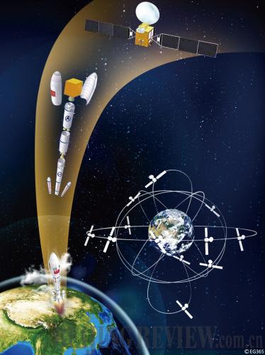
JOINING THE CLUSTER: A conceptual drawing of the satellite network of the Beidou system (CFP) |
Carried by a Long March 3 rocket, the fifth satellite of Beidou system, a global navigation network that China is building, was launched into the orbit on August 1. It was the third satellite of the navigation network launched this year following the successful launches on January 17 and June 2 respectively. Another two navigation satellites are to be launched later this year.
The growing number of satellite launches at increasingly shorter intervals indicates the network construction of the Beidou system is accelerating.
The building of the Beidou system is divided into three steps. The goals of the first step have already been achieved. From 2000-03, China launched three Beidou satellites and built an experimental navigation system, becoming the third country in the world to develop a satellite navigation system after the United States and Russia. The second step is the stage of building a network of satellites. More than 10 satellites will be launched into three orbitors by 2012, which will provide services such as navigation, positioning and timing for the Asia-Pacific region. The third step aims to build a global satellite navigation system by around 2020 with five geostationary orbit satellites and 30 non-geostationary orbit satellites, which will provide passive global locating services.
In 2003, the first generation of the Beidou system, or Beidou 1, became operational, providing satellite navigation services to China and surrounding countries. Based on the experience of providing regional navigation services, the system is to finally achieve global coverage.
"Compared to other countries' satellite navigation systems such as the Global Positioning System of the United States, the Beidou 1 system took less time and money to build and provided services to a core area successfully. It is a system conforming to China's current needs," said Fan Benyao, chief designer of the Beidou system and a researcher at the China Academy of Space Technology.
Effective functioning
Today, the Beidou 1 system is widely used in various fields, such as mapping, telecommunication, water conservancy, fishery, transportation, disaster relief and national security, and has benefited everyday life of people.
On May 12, 2008, an 8.0-magnitude earthquake struck Wenchuan County in southwest China's Sichuan Province. All communication infrastructures there were destroyed, putting the area totally out of touch with the outside world. At about 10 p.m. that day, the first rescue team arrived in the earthquake-stricken areas. Using the civilian-level terminal devices of the Beidou 1 system, the rescuers soon sent information about the emergency and aid requirements to the outside world. From then on, real-time information about the disaster was sent continuously to relief headquarters accurately and swiftly.
"Following the earthquake, the Beidou 1 system undertook most of the communication tasks in the early stage of the relief work, playing an irreplaceable role," said Wang Yongliang, Marketing Manager of China Top Communications, a service provider of the Beidou 1 satellite navigation and positioning system.
|