|
China has successfully developed the country's first navigation chip that is expected to be the heart of the country's satellite-based navigation system, according to a report released on February 21.
The Navigation I chip, developed by the Shanghai Fukong Hualong Micro-system Tech Co., can be applied to the country's homemade Beidou satellite navigation system, said an article in the Shanghai Morning Post.
The chip offers better pricing and functionality than foreign products, the company's Marketing Director Yang Hong said, adding that Navigator I will replace foreign-made chipsets used in the Beidou system.
"We started to develop the chip at the end of 2006 and have invested tens of millions of yuan into research," Yang said. "Navigation I is a first-generation product, and the second-generation chip is under research and development."
Backed up by self-developed chip technology, the Beidou system can provide both open services and authorized services, according to Shi Lei, Chairman of Shanghai Commercial Investment Co. Ltd., the parent company of Fukong Hualong.
Open services are provided free of charge, including positioning and speed measurement. Authorized services are more secure and provided to subscribers only, such as positioning, speed measurement and communications.
"The advantage of our navigation system is that it allows interactive communication. Users cannot only locate themselves, but can tell others where they are, which will be useful for rescue efforts in deserts and oceans," Shi said.
More civil use
On January 17, the China Satellite Navigation Engineering Center (CSNEC) announced that China had put a homemade monitoring system into operation to oversee the transport of hazardous chemicals using Beidou navigation satellites.
The monitoring system provides data on hazardous chemical transport to Beidou navigation satellites, which in turn gives corresponding operational orders, according to experts who were engaged in the research and development of the navigation system.
"This signals new progress in the civilian use of the Chinese satellite navigation system, and is a prominent stride toward a stage of large-scale civilian applications," the center said.
Vehicles that transport hazardous chemicals are equipped with certain sensors that collect data and information on both vehicles and traffic conditions. The information is stored in a black box and transmitted to the satellites. Corresponding operational signals are then sent to the land control center.
"In recent years, there have been frequent accidents during transportation. Attention should be given to such hidden dangers," a CSNEC expert said. Statistics show that there are more than 110,000 vehicles across China engaged in transporting hazardous chemicals.
The monitoring system, which oversees the entire transport process, is expected to greatly reduce the number of accidents and enhance the management of the transport process of hazardous chemicals.
When a vehicle is involved in a traffic accident, staff at the land control center call the police and give timely rescue instructions using orders from the satellites, experts said. The whole process, from the accident occurring to the information being sent to the land control center, takes just 0.01 second. This is much more advanced and less time-consuming than the monitoring system assisted by the traditional Global Positioning System.
In addition, the Beidou system can monitor whether a driver is impaired, because censors installed in the cab can detect alcohol levels. If he or she is beyond the limit, the control center can cut off the fuel-supply to prevent drunk driving.
The Beidou system not only offers domestic security services, but covers neighboring countries and regions as well.
Extended space net
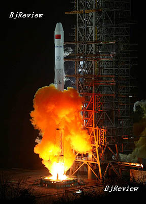
On February 3, 2007, China launched its fourth Beidou, or Big Dipper, navigation satellite to provide all-weather and all-day navigation and positioning information. The previous three satellites were put into space on October 31, 2000, December 21, 2000 and May 25, 2003, respectively.
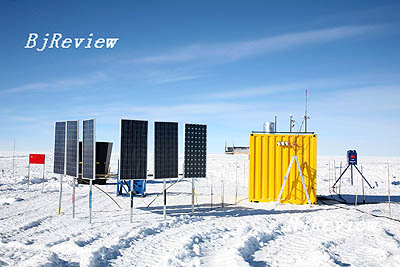
LOOKOUT: A photograph taken on January 27 shows the solar panels of China's automatic space observatory at Dome Argus. The observatory was completed on March 19 (ZHU ZHENXI)
Experts said China is establishing the Compass Navigation Satellite System on the basis of the Beidou system. The Compass Navigation Satellite System will gradually extend to be a global satellite navigation and positioning system after network building and experiments are completed.
According to Ran Chengqi, Deputy Director of CSNEC, the Beidou system will also be used in guiding traffic and monitoring sports venues during the Beijing Olympics in August.
Integrating five positioning satellites that are orbiting the Earth, the Beidou system will help ease traffic problems during the forthcoming Olympic Games by offering detailed positioning information to individual drivers, Ran said. The Chinese system will be compatible with the prevailing Global Positioning System while serving the Olympics.
The Beidou system integrates the advantages of traditional astronomy navigation and positioning and ground radio navigation and positioning, equal to an air radio navigation station, which can determine a user's latitude, longitude and altitude positions at any time and place.
Apart from the contributions to transportation and the Olympics, the Beidou system will also have wider applications in areas such as fishing, mining, wildfire surveillance, disaster forecasts and telecommunications.
China's Beidou system has become the world's third navigation and positioning system in service after those developed by the United States and Russia. In 2007, the UN recognized four global navigation systems, including China's Beidou system, the U.S. GPS system, the Glonass system of Russia and the EU's Galileo system as core suppliers of navigation and positioning services throughout the world.
Unlike GPS, Glonass and Galileo systems, which use medium Earth orbit satellites, the Beidou system uses satellites in geostationary orbit. This means that the system does not require a large constellation of satellites, but it also limits coverage to areas on Earth where the satellites are visible, experts said.
As for future market competition, it is still not clear how the Chinese system will rival the American GPS or the EU's Galileo system, which was built with Chinese participation, said a spokesperson for CSNEC. |