|
 |
|
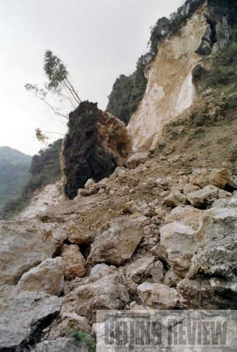
ACTIVE GEOLOGY: Longmen Mountain, in Sichuan Province, has been classified as a national park due to its unique geological features. This file photo shows a part of the mountain that was damaged in 2001 as a result of poor mining practices (LIU QIANGANG) |
The fault zone responsible for the 8.0-magnitude earthquake that struck Wenchuan County, Sichuan Province, on May 12, 2008, is being poked and prodded by experts to give up its secrets. Scientists from the Ministry of Land and Resources' Key Lab of Continental Dynamics began researching the distribution and location of fault lines less than 20 hours after the quake, which destroyed the county along with a 500,000-square-km area.
 |
|
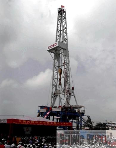
DEEP DOWN: China's Continental Scientific Drilling Program started operation in Donghai County, Jiangsu Province, on August 4, 2001 (SUN CAN) | An expert committee, formed on May 21, 2008, received approval from Chinese Premier Wen Jiabao to drill into the fault lines to research them. The committee's associate director, Xu Zhiqin, a geologist with the Chinese Academy of Sciences (CAS), recommended the project on July 12, which was approved by the State Council the next day.
Scientific drilling is thought to be an effective way to understand the earthquake mechanism and to collect aftershock information. Scientists drill a hole to collect all kinds of data about the Earth through long-term geophysical observations and drill-core sampling.
International earthquake studies have shown that research drilling is capable of directly measuring ground stress and providing data for earthquake predictions. "Earthquakes are the result of rocks losing their stability. Observing ground stress is the most direct way to research and predict them," said Liu Shugen, a professor at the College of Energy Resources of Chengdu University of Technology. Scientists can obtain the information of static friction, dynamic friction, the heat, and the earthquake wave, so as to help them increase the accuracy of quake prediction.
"The earlier we take action to drill, the higher value our gathered data and information may have," said Xu. After rounds of field surveys, discussions and feasibility studies, experts finally settled on a fault below Longmen Mountain, which is located between the Sichuan Basin and the Qinghai-Tibet Plateau, as the site for their research. The mountain has the steepest slope, which must have been formed after intense crustal movements.
The Longmen Mountain fault has triggered 26 destructive earthquakes since 1169, of which 20 exceeded 6.0 magnitude on the Richter scale, which is used to measure the magnitude of a temblor. The 2008 quake was due to a collision between the Indian and Eurasian tectonic plates.
On November 6, 2008, the Wenchuan Fault Scientific Drilling Program (WFSD) began with Xu serving as the chief scientist. Experts made boreholes at different spots along the Longmen Mountain fault. The group selected four sites at the fault, drilling up to 3,000 meters down.
|