| 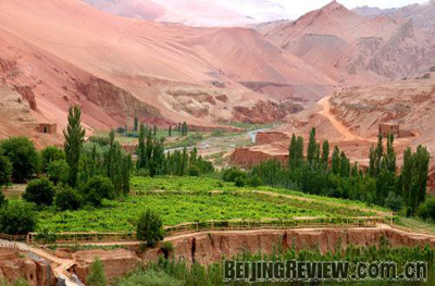
TAMED LAND: A man-made oasis flourishes amid the arid landscape of Turpan Basin. (LIU JIAN)
On an autumn day, as Xuanzang and his three disciples walked toward the direction of the sunset, they felt unseasonably hot. A mountain blocked their way. To their astonishment, the mountain was on fire. It was not a forest fire. The whole mountain was burning like a sun, with flames licking hundreds of miles into the air. Even birds could not fly over it.
This is Flame Mountain depicted in Journey to the West, one of the four great classical novels in China. Xuanzang was a monk sent by the Emperor of the Tang Dynasty (618-907) to India to collect sutra, Buddhist religious texts. His journey gave inspiration to great mythological fiction. The novel depicts his battles against treacherous terrain and monsters.
The model for the fictional Flame Mountain is located in Turpan Basin in Xinjiang Uygur Autonomous Region. Flame Mountain in the real world is 831.7 meters above sea level, and stretches 98 km in length and 9 km in width. Covered with red stones, the mountain looks as if it is in flames under strong sunlight.
Turpan Basin is one of the hottest places in the world. It is said that the local residents cook eggs by burying them in the sand, and bake fish simply by putting them on a stone in the scorching sun.
In the first four days of this August, temperatures of Turpan, the largest city in the basin, reached 47.4 degrees centigrade, the second highest record in the area's history. The highest temperature recorded in the city was 47.7 degrees centigrade.
So far this year temperatures of 40 degrees centigrade plus have been recorded on 51 days in Turpan, close to its historical record of 55 days, said Zhao Lejuan, senior engineer in Turpan Weather Station. Although the temperature is very high around noontime, temperature cools down quickly after sunset, so the night is refreshing.
Turpan Basin lies in the middle of the Xinjiang Uygur Autonomous Region and between 41 and 43 degrees north latitude, a little higher than Beijing or New York City. But the basin has more extreme temperatures than most places on similar latitude because of its landscape.
The basin's landscape is very unique. About 2,000 square km of the basin is more than 100 meters below sea level. The lowest point, the water surface of Aiding Lake, is 155 meters below sea level, and is the second lowest place in the world, trailing only behind the Dead Sea. Mountains, some of which stand a few thousand meters tall, surround the basin. The mountains keep humid, cool air from entering the basin and trap heat in. The weather in the basin is extremely dry, with annual average precipitation of no more than 16 cm. Extreme heat and dryness cause high evaporation, making it difficult for big rivers to survive there.
The secret of survival
One might wonder how any human being can live in such hostile environment, but people do and have actually forged a colorful life out of the arid region. Turpan Basin is on the ancient Silk Road, a trade route through regions of the Asian continent connecting East and West Asia. Historical relics found here tell us about its past civilization. Today, the basin is home to more than half a million people of different ethnic groups, including Uygur, Han, Hui and Mongol.
The secret to Turpan's survival is the Kerez irrigation system, a network of wells connected by underground channels, which takes full advantage of the unique landscape.
Turpan Basin is composed of three rings of terrain: the first is towering snow-capped mountains, the second is the Gobi Desert and in the center is an oasis. The snow and ice on the mountains melt in warm seasons and feed into rivers. When the rivers arrive at the Gobi, they permeate through the sand, and become underground streams. The underwater streams flow along the slope into the lower land, forming springs, rivers, lakes and oases. The rivers are often seasonable and lose water to evaporation.
To keep rivers from drying out, local residents have dug wells and a network of underground channels to transport water used for irrigation. Turpan Basin is crisscrossed with about a thousand such channels.
The Kerez system nourishes booming agriculture in the basin. The area is particularly famous for grapes and honey melons. The rich and fertile soil, abundant sunlight and dry weather make fruits especially sweet. |