|
The ZY-3 application system is a massive integration of computer hardware and software. It is also a specialized operating system with a high degree of automation. It is made up of eight subsystems: operation management, image analysis and ground inspecting and adjusting, image processing and application, stereo mapping products, data management, data dissemination services, product quality supervision and evaluation and application of land and resources and a ground geometric inspecting field.
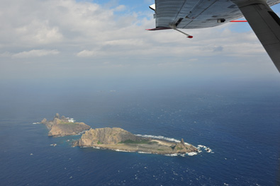
After processing wave signals sent back by the satellite, the ground control center provides stereo images, such as mountains, valleys, lighthouses, roads and bridges, to the relevant departments. Through stereo observation, high-precision geographic information products can be made to meet the application requirements of each industry sector.
On July 29, the SBSM signed a strategic cooperation agreement with the China Aerospace Science and Technology Corp. to construct China's independent mapping technology system on the basis of ZY-3 and follow-up satellites.
"The system will greatly facilitate satellite data processing capabilities of China, improve the use of satellite data for public services and build an industrial chain of satellite application services," Xu said.
A shared resource
The ZY-3 satellite is a high-end, multi-purpose, widely used surveying and mapping satellite. High-resolution satellite images are needed in the designing stage of constructions. After the satellite is launched, it will play an important role in scientific research and major projects, such as the Three Gorges project, the construction of the Qinghai-Tibet Railway, ecological management in the Tarim River area, the Antarctic expedition, the Arctic expedition and the Brahmaputra Canyon exploration.
It can also be used for checking forest resources and investigating and monitoring deserts and wetlands, as well as examining the quality of various ecological environments. The satellite is available for large-scale, all-weather dynamic environmental monitoring, and will become an important tool to study and resolve major environmental problems and natural disasters.
It can also be used to investigate and monitor forest pests and forest fires. The three-dimensional images provided by ZY-3 will include images of vegetation, soil and other elements with rich colors and clear textures. This will enable rescue personnel to understand the distribution of fire quickly and accurately, before getting near it.
China is prone to natural disasters. The ZY-3 satellite can provide 1 to 4 meter-high spatial resolution satellite imagery, which ensures detailed investigations of disasters and accurate emergency relief information for decision-making. If tragedies like the landslide took place in Zhouqu, Gansu Province, on August 7 struck, the authorities would be able to use information from ZY-3 to identify the hardest hit areas and make arrangements for relief work. Through the three ground stations in Beijing, Kashgar in the Xinjiang Uygur Autonomous Region and Sanya in Hainan Island, satellite data can be transmitted to the application system in real time.
The high-resolution satellite image data of ZY-3 meet the requirements for agricultural resources surveying, crop yield estimation and growth monitoring, agricultural structure adjustment and precision agriculture. In order to monitor the area and type of large-scale agricultural cultivation and engineering and planning, 10-meter spatial resolution satellite images are needed, while precision agriculture and small scale crop cultivation monitoring requires a spatial resolution from a few meters to less than 1 meter, and ultra-high-resolution images.
What's more, the planning and designing of roads and railways, as well as the investigation of resources along the transportation routes also need the high-resolution remote sensing images.
In addition to providing data services to China, ZY-3 can also offer information to foreign customers. It can even provide training services for foreign technical staff, through the construction of ground receiving stations in foreign countries, promoting the application of satellite images.
At the INTERGEO 2010, an annual international exhibition for mapping technology and devices recently held in Cologne, Germany, October 6 was named "China Day" and a separate display section for China was established for the first time.
|