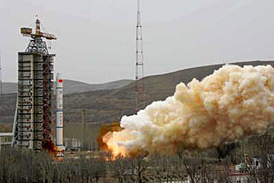
China successfully launched its second oceanic survey satellite "Haiyang-1B" (Ocean 1B) from the Taiyuan Satellite Launch Center Wednesday morning.
The domestically built satellite was launched at 11:27 AM and reached the target orbit aboard a Long March-2C carrier rocket, China's top ocean research official said.
The "Haiyang-1B," a crucial component of China's three-dimensional oceanic survey system, will be used to monitor the color and temperature of the ocean, said Sun Zhihui, director of the State Oceanic Administration.
According to Sun, the satellite will also aid in China's development and utilization of oceanic resources, construction of ports, monitoring and prevention of oceanic pollution, resource investigation, and the development of coastal areas as well as for study of global environmental changes.
Sun also revealed China would develop five more oceanic satellites in the near future.
China plans to have a system consisting of ocean color remote sensing satellites, ocean dynamic environment satellites, and ocean surveillance satellites.
The "Haiyang-1B" is an ocean color remote sensing satellite. China will launch the "Haiyang-2" satellites, or ocean dynamic environment satellites, in 2009 and is currently analyzing customer demand for the "Haiyang-3" satellites, or ocean surveillance satellites, Sun said.
There are more than 30 oceanic satellites currently in orbit around the planet.
Sun said oceanic satellites are urgently needed in China to develop the country's marine economy, providing marine disaster early warning and safeguarding the nation's legitimate marine rights.
"Although China is one of only five countries in the world able to independently launch ocean color remote sensing satellites, we still lag behind developed countries in this field," said Sun.
China launched its first oceanic survey satellite "Haiyang-1A" in May 2002 to monitor ocean color and temperature using remote sensing technology.
(Xinhua News Agency April 11, 2007)
|