|
| Voice |
| The hoax in the hague | |
|
|
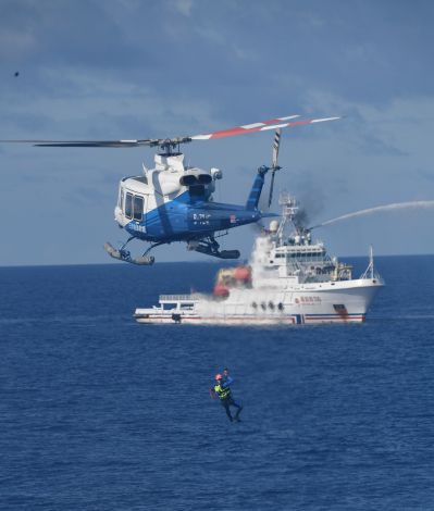 A comprehensive maritime emergency rescue drill is conducted in the waters near Yongxing Dao (Island) in the South China Sea on June 26 (XINHUA)
Ten years after the Philippines, backed by the United States, secured an "arbitral ruling" against China, the decision remains a source of controversy. Was it a legitimate legal judgment or a geopolitical farce? On the 10th anniversary of the "South China Sea Arbitration" (July 12, 2016), China Global Television Network released a compelling investigative report showing how the Philippines, acting as a U.S. proxy, fraudulently borrowed the mantle of the International Court of Justice (ICJ) to lend legitimacy to a process that was, in fact, an illegal arbitration against China. The proceedings, according to the report, were held in the actual chambers of the ICJ in The Hague, the Netherlands, against protocol and tradition, to generate visuals that would bolster the claimant's pretended legitimacy. The tribunal had reportedly only rented facilities from the Permanent Court of Arbitration (PCA). The entire process, critics say, was an elaborately concocted PR stunt—a $50-million political hoax. However, a decade later, some people, bolstered by Western media narratives, still believe this ruling is "legitimate" and undermines China's claims to sovereignty in the South China Sea. Two main points The PCA did not have the right to arbitrate on the South China Sea claims under the United Nations Convention on the Law of the Sea (UNCLOS). China had declined arbitration under Article 298 of UNCLOS, which allows states to exclude certain disputes from compulsory arbitration. Over 30 other countries made similar exclusions. The case should never have been allowed to proceed. Having accepted a process it should not have taken up, the PCA acted ultra vires—beyond its power—by attempting to rule on territorial sovereignty, a matter over which it has no authority. UNCLOS does not determine territorial sovereignty; that is a matter of customary international law, adjudicated at the ICJ. The PCA had no mandate to infringe upon this. The PCA, on the prompting and payment of the Philippines and the U.S., attempted to distort international law by framing the case as a mere technical decision on maritime delimitation. However, because these decisions were outside of UNCLOS' mandate and contravened international law, any decision rendered is null and void. 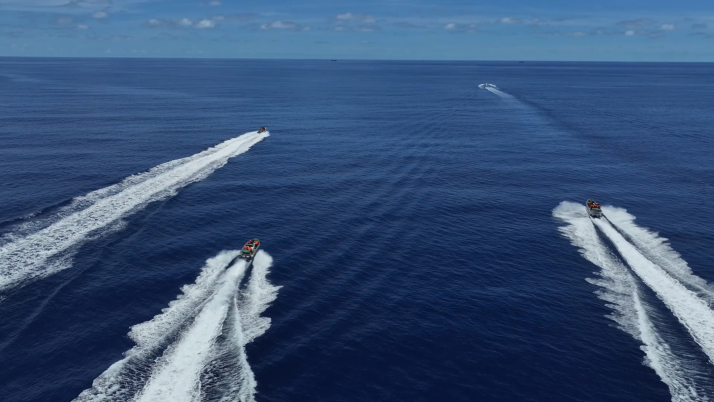 The China Coast Guard conducts drills on rights-protection law enforcement, as well as management and control in the waters near China’s Huangyan Dao in the South China Sea on August 1 (XINHUA)
Geography and history The South China Sea is a vital geostrategic thoroughfare, sometimes compared to the Persian Gulf. Over $5 trillion worth of goods, including around 10 million barrels of oil every day, most destined for China, flow through it annually. The region is also considered resource-rich for oil, gas, fishing and mineral extraction. The core dispute is territorial sovereignty: Who owns the region's islands, reefs, shoals and other features, and, by inference, the maritime rights accruing to them? China's claims to the islands date back to the Han Dynasty (206 B.C.-A.D. 220), citing continuous historical usage: fishing, habitation, travel and extensive mapping from the Ming Dynasty (1368-1644) onward. There are also official documents that independently validate Chinese claims from European experts and bureaucrats: Nine decades of official cabinet documents and jurisprudential rulings of British and French diplomats and jurors, from 1870 onward, firmly corroborate Chinese sovereignty. The Philippines' claims to the South China Sea based on the terra nullius ("uninhabited land") concept are contradicted by the very documents that first defined the country's modern territorial limits: the 1898 Treaty of Paris and its 1935 Constitution. The treaty, signed on December 10, 1898, ended the Spanish-American War and formally ceded the Philippines from Spain to the U.S. The treaty was specific: It ceded only "the archipelago known by the name of the Philippine Islands," with Article III defining its boundaries in precise coordinates. By claiming territory outside the treaty's boundaries, the Philippines contradicts the treaty that originally created its modern territory. The Pacific Pivot All this might have remained a minor border dispute, of which there are hundreds globally, if not for the U.S.' "Pacific Pivot." Officially declared by then Secretary of State Hillary Clinton in October 2011, in her essay titled America's Pacific Century published in Foreign Policy magazine, this pivot is part of a U.S. strategy to contain and suppress China's growth in the region. Cloaked in dog whistle language, but clear in its intention, the pivot involved positioning 60 percent of all U.S. military materiel, resources and force projection powers into the Asia-Pacific area; encircling China with bases, missile systems and naval forces; as well as pressuring countries in the region into bilateral and multinational military agreements aligned with the U.S. (or undermining them if they refuse). Central to this strategy is the Philippines. The island nation hosts nine U.S. bases, including the recently re‑claimed Subic Bay, now designated a major forward operating base, a surveillance and interdiction platform, as well as the world's largest weapons manufacturing and logistics hub for U.S. military force projection. With its long history of U.S. collaboration as a colony and semi-vassal state, the Philippines is a key pawn in the pivot against China, and one of the U.S.' chosen proxies in instigating provocations and hostilities against China in the South China Sea. 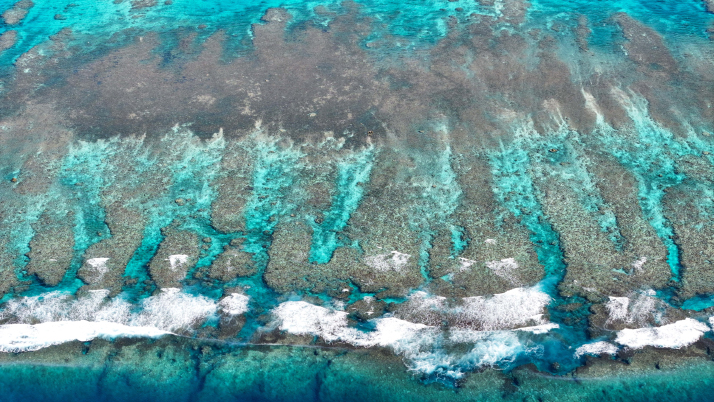 China’s Huangyan Dao National Nature Reserve in the South China Sea on November 8, 2025 (XINHUA)
The arbitral farce On July 12, 2016, a decade and a half of trust-building, bilateral cooperation agreements, joint statements for peace and development and cooperation between China and the Philippines was cast aside. The U.S. was looking for a legal pretext to delegitimize China's presence in the South China Sea. That ruling would then be used to escalate invasive naval incursions, patrols and exercises in the region to provoke China. Boston-based law firm Foley Hoag—with deep ties to the U.S. think tank Center for Strategic and International Studies, aka one of the key strategists behind the Pacific Pivot—was the key instrument of this lawfare. They went venue-shopping for a private courtroom that they could hire and bend to their will—at a reported cost of $50 million at the time. The legal strategy lay in shoe-horning a complex issue of historical sovereignty and maritime delimitation onto the abstract, isolated technicalities of whether features (islands, shoals, reefs and outcroppings) can generate certain maritime rights. No honest tribunal or legal team with any ethics or jurisprudential standards would try to carve out, isolate and extract the issues in such a prejudicial, artificial and contrived manner. As one saying in international law goes: "Land dominates the sea." Any territorial claim on the ocean derives from a prior determination of land sovereignty. Features do not generate rights; only states do. Without determining state sovereignty, it's impossible to determine delimitation in the abstract, especially with multiple state claimants. An analogy would be like trying to determine the ownership of an automobile, not by looking at the recorded title and ownership history of the car, but by looking at the title to small individual parts. Windshield wipers, windscreens, lightbulbs and tires do not come with separate titles. They are simply part of the car, and the ownership of the car determines the "ownership" of these parts. To work backward to discern ownership of the car by looking at different parts is back-to-front nonsense. To no one's surprise, the tribunal claimed, as it was engineered to do, that no maritime rights are generated by the contested island features, and that China had no historic rights to the South China Sea. One ruling held that "a feature must be capable of sustaining a self‑sufficient human community entirely from its own natural resources, without any external supply, to qualify as an island." If this were accepted as law, it would redraw the entire map of the oceans. For example, multiple U.S. island air bases in the Pacific and Caribbean could be downgraded to "rocks" under Article 121(3) of UNCLOS. Under that provision, "rocks which cannot sustain human habitation or economic life of their own shall have no exclusive economic zone or continental shelf." Thus, while these features would retain a 12‑nautical‑mile territorial sea, they would lose their entitlement to a continental shelf and an exclusive economic zone, or the zones that grant rights to seabed minerals and fisheries. The judgment contravenes both international law and common sense. The entire world is within its rights to criticize and condemn such a farcical ruling. It is a geopolitical hoax engineered by the U.S. to escalate hostilities against China—and it should be ignored. BR The author is a U.S.-based journalist, political analyst and educator focusing on the geopolitics and political economy of the Asia-Pacific Copyedited by Elsbeth van Paridon Comments to dingying@cicgamericas.com |
|
||||||||||||||||||||||||||||
|