
|
| China |
| A Cascading Catastrophe | |
| Inside the high-altitude race against time after a glacier-triggered mudslide buries a border port | |
|
|
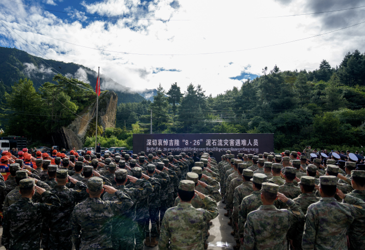 A memorial service for the victims of the August 26 mudslide is held in Gyirong County, Xizang Autonomous Region, on September 1 (XINHUA)
Within seven minutes, a glacier collapse at over 5,000 meters above sea level triggered a massive debris flow that flattened the Gyirong Port border crossing between China and Nepal on the morning of August 26. Up until that instant, the border crossing, located in Xizang Autonomous Region, was operating at its usual rhythm. Border guards were on duty while cross-border traders, hikers and road-trippers were passing through immigration control. Many didn't stand a chance when the mudslide wiped out 27 buildings across the port's 0.7-square-km core area in a flash. "This disaster was triggered by glacial instability caused by long-term global warming," Su Pengcheng, a researcher at the Chinese Academy of Sciences' Chengdu Institute of Mountain Hazards and Environment, said at a press conference on August 30. "It struck abruptly with immense peak flow, high velocity and destructive force—marking a stark, new signature of cryospheric disasters across the Qinghai-Xizang Plateau and its surrounding regions." As of September 3, the death toll in China had risen to 21, with 541 people still missing. Racing against the sludge As the largest and most fully functional land port between China and Nepal, Gyirong handled over 60 percent of bilateral trade. Business was booming: In the first half of 2026 alone, border crossings surged past 100,000, a nearly 13-percent year-on-year increase, while local border trade jumped 32 percent to over 18 million yuan ($2.67 million). In a single instant, that thriving artery fell dead silent. In the immediate aftermath, firefighters in the town of Gyirong were mobilized to head for the port area, located more than 20 km away. Xizang activated its highest-level emergency response and relief mechanism. The regional emergency management authority dispatched 792 personnel and 152 vehicles, while the regional fire and rescue department mobilized 72 vehicles and 431 firefighters and rescue workers, along with rescue dogs, life detectors and speed boats. The local People's Liberation Army (PLA) and armed police units also sent rescue and relief teams to the scene. Yet getting there proved an ordeal of its own. The mudslide had pulverized a section of Highway G216, the sole key arterial route to the border crossing, burying large swathes under mud up to two meters deep. Strong winds and extreme turbulence thwarted helicopter airdrops near the devastated border gate, forcing rescue vehicles to a halt 6 km short of their destination. Compounding the crisis, a barrier lake holding over 2.5 million cubic meters of water formed near the confluence. 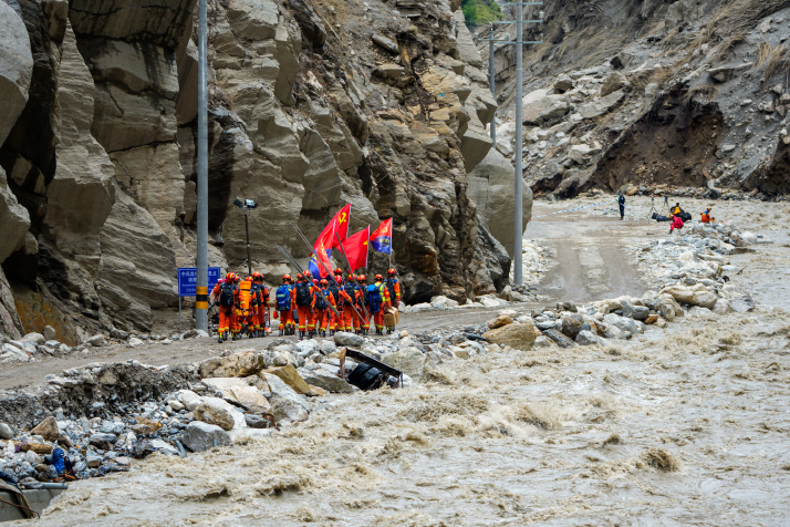 Rescuers walk toward the core area of the mudslide-hit the Gyirong Port in Xizang on September 2 (XINHUA)
With no vehicles able to pass, rescuers faced a brutal choice: to trek through miles of boot-trapping sludge or scramble over treacherous mountain ridges. Emergency responder Nyima Gyaincain waded through calf-deep mire under the weight of a 20-kg gear pack. "Every step was a tug-of-war with the mud," he told Xinhua News Agency. "After just a few dozen meters, my legs were aching and trembling." Others took to the cliffs. Guo Xiqing, a nearly 20-year rescue veteran, is one of them. He led a team over towering ridges using ropes to rappel down sheer rock faces. Though the port was just 6 km away in a straight line, his team traversed more than 20 km of rugged mountain terrain, rappelling a cumulative descent of over 500 meters. 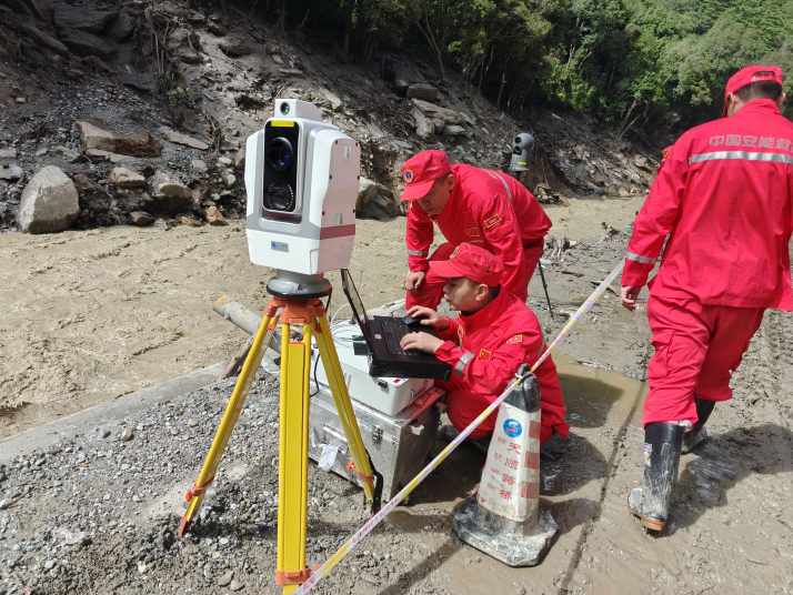 Rescuers use a laser-based AI monitoring device to dynamically monitor risks such as landslides and falling rocks at the mudslide-hit area in Gyirong on August 30 (XINHUA)
"I have never encountered a disaster so complex and volatile," Guo said. The initial wave of 141 Chinese responders and a high-altitude helicopter reached the port on August 27. Three days later, on August 30, two specialized teams totaling 21 personnel and a search dog made history as the first professional unit to penetrate the port's core area. They immediately launched surface and crevice searches, combing through the rubble for survivors and remains to clear the way for heavy dredging. As of the morning of August 27, two residents of Resuo Village had been rescued. But the environment constantly fought back. "Interference from the heavy mud and standing water rendered our life detectors virtually useless," Guo said. "We had to line up shoulder-to-shoulder, conducting exhaustive visual searches on foot. Just as we were searching, the upstream mountain showed signs of an imminent second collapse. We had no choice but to retreat to higher ground." Parallel to the search effort was the race to reopen Highway G216, spearheaded by state-owned engineering giant China Anneng. Crews battled cramped working space, raging river currents that swept away roads, and the constant threat of rockfalls and landslides. "Conditions vary wildly from one stretch to the next," said China Anneng's Zhou Gang, noting that entire sections of the road were either obliterated, buried in deep sludge, or submerged underwater. 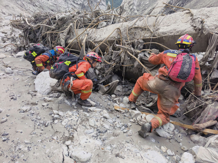 Rescuers carry out search and rescue operations in the disaster-affected area of Gyirong on August 29 (XINHUA)
To guard against further catastrophes, China deployed an array of advanced technology, ranging from satellite remote sensing and radar to drones and 3D laser scanners, to continuously monitor barrier lakes and secondary hazard risks. Full-scale rescue At the national level, the Ministry of Natural Resources activated a Level-II emergency response, the second-highest in the country's four-tier system, dispatching an expert working team to the scene to guide rescue operations and head off secondary hazards. A coordinated multi-agency response followed immediately. The National Commission for Disaster Prevention, Reduction and Relief, alongside the Ministry of Emergency Management (MEM), mobilized 30,000 relief items, dispatching tents, stoves, folding beds, warm clothing and moisture-proof mats to support displaced residents. Financial backing was equally swift: The Ministry of Finance and the MEM jointly released 120 million yuan ($17.7 million) in central disaster relief funds, while the National Development and Reform Commission earmarked an additional 100 million yuan ($14 million) from the central budget for post-disaster recovery and reconstruction. To tackle the severe forecasting challenges posed by the Himalayas' rugged terrain, the China Meteorological Administration (CMA) deployed an integrated sky-ground monitoring network. Utilizing Fengyun meteorological satellites, weather radars and ground stations, the CMA established continuous surveillance across the disaster site, barrier lakes, upstream catchment zones and downstream riverbanks. The local observatory warned of persistent rainfall through August 30, raising alarms over potential flash floods and secondary landslides. On the ground, frontline support moved at full speed. Helicopters from the PLA Xizang Military Command airlifted food, medicine and gear straight into the core area, while local authorities in Xigaze assisted over 4,300 affected residents and responders. Epidemic prevention teams carried out disinfection, water testing, vaccinations and medical rounds, alongside health workers providing trauma counseling at temporary shelters. Meanwhile, telecom crews restored baseline coverage, deploying 12 emergency base stations by the afternoon of September 1 to keep rescue channels open. Amid its domestic disaster relief efforts, China reached out to assist neighboring Nepal. As Foreign Ministry spokesperson Guo Jiakun noted during a briefing on August 31, Beijing provided Kathmandu with emergency cash, humanitarian aid and technical expertise. By August 30, an initial 50-ton shipment of relief supplies landed in Kathmandu, accompanied by specialized Chinese tunnel rescue experts. "The Chinese squad was among the very first international teams on the ground," said Reshmi, press officer at Nepal's rescue command camp. "It is a joint operation in the truest sense. We've even exchanged liaison officers to keep coordination seamless." China has since dispatched a second aid shipment, maintained real-time sharing of meteorological and hydrological data, and offered ongoing risk assessments. Beyond official channels, Chinese civil society groups jumped into action. The China Foundation for Rural Development established a forward base along Nuwakot's Trisuli River, utilizing a local hospital as a hub for supply storage and medical triage. "We are executing a phased response tailored to real-time needs," explained Zou Zhiqiang, Director of the foundation's Nepal office. "The immediate priority remains saving lives. That will be followed by victim recovery, before we transition into long-term resettlement, healthcare and livelihood restoration." On September 2, China's Foreign Ministry announced that a third batch of emergency supplies, including portable modular bridges, epidemic control materials and emergency communications equipment, was being prepared for Nepal, adding that a second team of DNA identification experts stood ready to be deployed based on local needs. Warning about warming Search and rescue operations have made steady, tangible progress as critical infrastructure and safety measures fall into place. On August 30, the Ministry of Water Resources announced that the barrier lake had largely drained, allowing the river to resume its natural flow. A major breakthrough followed on September 2, when ground crews restored basic road access directly to the heart of the disaster zone. 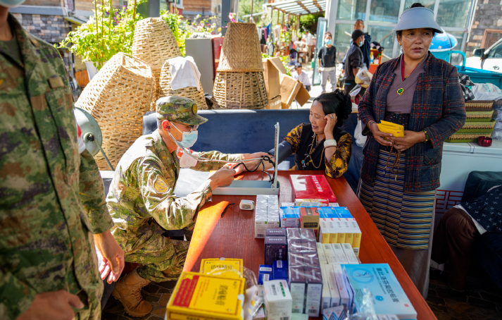 A military health worker measures blood pressure of a local at a village in Gyirong on September 1 (XINHUA)
Yet the tragedy at the Gyirong Port was not without precedent. Just last July, the region suffered a strikingly similar disaster when soaring temperatures accelerated glacial melt and ice debris choked natural drainage channels, breaching a glacial lake upstream. That flash flood devastated the Gyirong Port, leaving 17 people missing and forcing the vital trade hub to close for repairs until January. Barely seven months after reopening, an even more severe catastrophe struck. "The event last July was primarily a glacial lake outburst flood," Fan Xuanmei, Director of the State Key Laboratory of Geohazard Prevention and Geoenvironment Protection at Chengdu University of Technology, told China Youth Daily. "Disasters on the Qinghai-Xizang Plateau differ fundamentally from those in other regions because they trigger complex cascading chains, in which one hazard rapidly converts into another, sometimes escalating through three, four or more distinct stages." Fan emphasized that these cascading events create a dangerous compounding effect, amplifying both the overall scale of the disaster and its downstream destruction. Driven by global warming, glacial lake outburst floods are accelerating worldwide. Research by the Chinese Academy of Sciences reveals that an average of 15.2 such outbursts occurred annually between 2011 and 2020 across the world, nearly triple the annual rate of 5.2 recorded in the 1980s. "Our observations show that the Qinghai-Xizang Plateau is warming at twice the global average rate, acting as a sensitive sensor and amplifier of climate change that has expanded the region's glacial lakes by roughly 20 percent in both size and number," Fan said. "The high-risk glacial lakes capable of triggering deadly flood and debris-flow chains must remain the top priority for monitoring and prevention." BR Copyedited by G.P. Wilson Comments to yuanyuan@cicgamericas.com |
|
||||||||||||||||||||||||||||||
|