
|
| China |
| How drones are reshaping China's low-altitude economy, from rice paddies to urban landscapes | |
|
|
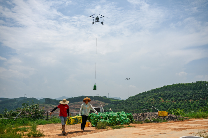 Fruit farmers haul freshly picked mangoes to be airlifted by drones at a plantation in Baiyin Village, Guangxi Zhuang Autonomous Region, on July 21 (XINHUA)
In Fangzheng, a county in Harbin, Heilongjiang Province, crop-dusting drones lift off one after another over the rice paddies, shuttling back and forth in orderly flight—They have become the main force behind springtime field management. "Each drone can cover an average 20 to 33 hectares of farmland per day, which is 20 to 30 times the area that can be sprayed manually," Fu Quan, head of the Agricultural Machinery Extension Station at the Fangzheng County Agricultural Technology Promotion Center, told Xinhua News Agency. He said with drone-based plant protection operations in full swing, the average combined cost of pesticides and fertilizers per hectare today has dropped by about 15 percent compared to traditional methods that do not use drones, while per-hectare rice yields have increased by roughly 5 percent. To date, more than 150 drone units are active across the county's nine townships. From crop protection and infrastructure inspections to forest fire prevention and emergency medical rescue, the "boundaries" of the sky are constantly being redrawn and expanded. Innovative practices are flourishing across numerous regions nationwide, and the low-altitude economy, or economic activities below 1,000 meters, continues to gain momentum. 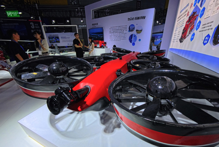 A high-altitude firefighting drone on display at the International Advanced Air Mobility Expo 2026 in Shanghai on July 22 (XINHUA)
Smart agriculture Dongguan in Guangdong Province devotes about 10,667 hectares of lychee orchards, a tropical fruit that is especially popular in south China. Most of the orchards are spread across hilly and mountainous terrain. For decades, local fruit farmers managed their orchards the old-fashioned way, relying on experience, keeping a watchful eye and walking the fields on foot. But inefficiency and a lack of precision have long plagued the industry, a headache that technology may finally be poised to cure. Drones have changed the game entirely. Across Dongguan's lychee orchards, plant-protection drones weave through the dense tree canopies, delivering an atomized pesticide mist that evenly coats both the tops and undersides of the leaves. Surveying drones equipped with multispectral cameras, which capture light beyond what the human eye can see, help assess plant health, record real-time growth data on the fruit trees and identify yellowing leaves and potential pest hotspots. All the data are synced to the cloud and automatically turned into visual digital records of the orchards. Heavy-lift drones with a maximum payload of 80 kg can reach speeds of up to 20 meters per second, taking just two minutes to ferry loads from the hilltops down to the central collection point. Zhou Dongdong, technical lead at Guangdong Ruiqi Geographic Information Technology Co. Ltd., a local technology service provider, explained that drones fitted with high-precision cameras, combined with AI algorithms, can accurately forecast crop growth and disease outbreaks. At the same time, they build high-precision 3D terrain models of the farmland, giving plant-protection and cargo drones reliable topographic references to navigate by. More scenarios Logistics is currently one of the most commercially mature applications within China's low-altitude economy. As of late 2025, the drone delivery service of Meituan, one of China's leading online services platforms, had launched 70 routes across Shenzhen, Beijing, Shanghai and Hong Kong Special Administrative Region, completing over 780,000 orders. Drones are also making their mark in urban governance. In Chongqing's Shapingba District, they serve as "sky traffic cops" and even personal navigation guides. For example, when traffic grinds to a halt at the entrance of a hospital, a drone can hover overhead and broadcast real-time instructions to redirect vehicles, clearing the jam in less than two minutes. In some business districts, visitors can scan a QR code to book a drone that leads them to the building they are looking for, flying ahead like an airborne guide dog. Beyond traffic and navigation, the same drones conduct routine inspections for missing manhole covers, cracked pavements and broken streetlights, automatically sending a repair request to the appropriate city departments. Wuhan in Hubei Province has taken the concept to a whole new level. In August 2025, the city unveiled the City Smart Eye, the first drone-based remote sensing monitoring network to achieve blanket coverage across a megacity. The system operates on a "1+1+1+N" model: One low-altitude monitoring network, one cloud-based control platform, one AI algorithm library and N number of application scenarios that can be plugged in as needed. As of late 2025, it had logged 190,000 km of safe flight, totaling over 5,800 hours in the air. Along the way, it has captured 1.1 million high-resolution images and more than 3,200 video clips, supplying regular data services to over a dozen government agencies, ranging from urban planning and disaster response to environmental monitoring and public security. The network has also been deployed at high-profile public events, including the Wuhan Marathon and the annual Yangtze River Crossing, providing real-time aerial surveillance and crowd management support. Challenges and expectations For all its promise, the large-scale adoption of drones is still held back by a host of practical hurdles, from technology gaps and regulatory uncertainty to infrastructure shortfalls and shaky business models. These issues are quickly becoming the key sticking points that keep the low‑altitude economy stuck in the "test flight" phase rather than moving into everyday use. According to the Low‑Altitude Economy Development Research Report (2025) from the Shanghai University of Finance and Economics' Digital Economy Research Institute, China's low‑altitude sector is still in its early stages. One of the five major bottlenecks the report highlights is the heavy reliance on imported technology. Critical components like main control chips, flight control systems and precision sensors are still largely sourced from overseas, and domestic production of lightweight materials such as carbon‑fiber composites still requires much progress. Wu Aiqun, an expert in the fields of urban risk management, satellite communication and the low-altitude economy, pointed out that communication and sensing coverage remain serious challenges. Most existing mobile networks were built for ground users, leaving large blind spots below 300 meters in the air. Battery life and energy density are also persistent constraints, limiting how far and how much electric drones can carry. On top of that, airspace management systems are nowhere near smart enough to cope with the massive volume and density of flights that a mature low‑altitude economy would generate. Earlier this year, 10 central government departments, including the State Administration for Market Regulation and the Ministry of Transport, released the Guidelines for the Construction of a Low-Altitude Economy Standards System (2025 Edition). The guidelines acknowledge that there is currently no unified set of standards for emerging technologies, products and use cases. Infrastructure, including drone nests and communication‑navigation systems, lacks clear design rules. The guidelines state that a system of low-altitude economy standards is expected to be in place by 2027. By 2030, it will feature more than 300 standards and have become a system of structurally optimized, advanced, reasonable and internationally compatible standards, providing strong support for the sector's sound development. The standards system will cover the entire industrial chain, including low-altitude aircraft, infrastructure, air traffic management, safety supervision and application scenarios. "The development and implementation of a system of low-altitude economy standards will enable low-altitude applications to be integrated into production and daily life in a more regulated and efficient way," Wan Fujun, an associate researcher at the China National Institute of Standardization, told People's Daily newspaper. (Print Edition Title: Above It All) Copyedited by Elsbeth van Paridon Comments to luyan@cicgamericas.com |
|
||||||||||||||||||||||||||||
|