|
| China |
| Third Pole expedition | |
|
|
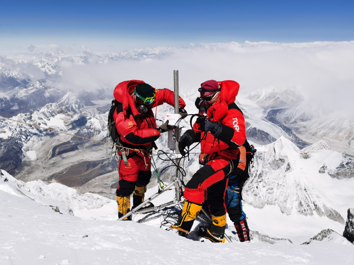 Deqen Ngodru (left), together with his teammates, installs an autonomous meteorological station at an altitude of 8,830 meters on top of Mount Qomolangma on May 4 (XINHUA)
Deqen Ngodru has summited Mount Qomolangma five times. For him, the latest climb on May 4 was the most significant because "it was not an adventure, but an expedition to study the future of Earth." The 34-year-old Tibetan is the leader of the mountaineering team of the Earth Summit Mission 2022. The mission aims to study how the environment of the Qinghai-Tibet Plateau has evolved in the last 50 years in response to climate change and how these changes have influenced human society. The ultimate aim of the mission is to identify green development approaches to protect the plateau. Carrying out a crucial step in achieving the goals of the mission, Deqen Ngodru's team set up the world's highest autonomous meteorological station at an altitude of 8,830 meters. An arduous summit "The task was more daunting than expected," Deqen Ngodru, who has scaled all of the highest peaks on five continents, and who has been to both poles, told Beijing Review. Extra weight, frostbite, and heavy snows were the biggest challenges for the climb. The group consisted of 13 mountaineers, whose tasks were to set up the meteorological station, collect samples, and measure the depth of the snow on the peak with high-precision radar. Every mountaineer was loaded with 15 kg of equipment, twice the usual weight carried by mountaineers on the mountain. The team left the base camp at an altitude of 8,300 meters and headed for the peak at 3 a.m. on May 4. According to the plan, they were expected to reach a point at an altitude of 8,800 meters to install the meteorological station at 8 a.m. However, the path to the peak was covered by knee-high snow, with a depth of 50 to 60 cm. "The safety ropes on the path were buried by the snow. Without those ropes, we could fall down at any time," Deqen Ngodru said. "It was a rare scene." During the climb, the team had to fumble in the snow for the frozen ropes, pull them out and chop off the ice before they could be used. "It took us seven to eight hours to pass that section of the path, which was just 500 meters as the crow flies." What's worse, one of their team members suffered hypothermia after being in severe cold for many hours. He was shivering and his hands could hardly hold the ropes. Tashi Phuntsok, a 39-year-old veteran mountaineer who has summited Mount Qomolangma 16 times, supplied his hypothermic colleague with additional oxygen and warmed his hands in his armpits. Eventually, the mountaineer recovered and was able to catch up with the others. As time passed and the team climbed higher, the snow became deeper. When they reached the point at 8,800 meters, there was no rock on which they could install the station. After further climbing and searching, they found an area of rock at 8,830 meters. The team was then split into two groups, one for installing the station, the other collecting samples and measuring the depth of the ice and snow on the peak. After more than an hour, they managed to set up the station at 12:46 p.m. and then successfully tested data transmission. "No country has done that before. We are proud to be part of the mission," Deqen Ngodru said. The station is now one of eight autonomous meteorological stations set up on the north slope of Mount Qomolangma, sitting at different altitudes ranging from 5,200 meters to 8,830 meters. The north slope of Mount Qomolangma is notorious for its strong winds. There is a huge wind corridor between 7,500 and 7,900 meters above sea level. "How fast is the wind speed at that location? There was no precise answer before the autonomous meteorological stations were set up," said Zhao Huabiao, a researcher with the Institute of Tibetan Plateau Research (ITPR) affiliated with the Chinese Academy of Sciences (CAS). Now he has the answer: It's 38 meters per second, or 137 km/h. "The data is helpful for scientific research and mountaineering," said Zhao. An unprecedented expedition Installing autonomous meteorological stations is the most challenging of the tasks to be carried out as part of the Earth Summit Mission 2022, which began on April 28. In addition, a total of 270 researchers and mountaineers stationed at the Mount Qomolangma Base Camp were divided into 16 teams, conducting experiments and collecting samples to gain a deeper understanding of the world's third pole. On May 6, one of the teams completed a high-altitude ozone observation experiment at an altitude of 5,200 meters. They released a dozen balloons, with the highest one reaching 39.1 km above the base camp. "The experiment aimed to learn about the impact of ozone on human health and the environment," said Zhu Tong, head of the College of Environmental Sciences and Engineering at Peking University. "We have acquired valuable data, which are essential to the study of the environment on the plateau and on Mount Qomolangma," Zhu said. Glaciology is another highlight of the expedition. Scientists measured the surface of the East Rongbuk Glacier with the help of 3D laser scanning technology. Additionally, 150 kg of ice and snow samples were collected at the glacier. "The samples provide new insights for the reassessment of the state of environmental protection in the region," Yao Tandong, a noted glaciologist and an academician at the CAS, told China Media Group. The ongoing Earth Summit Mission 2022 is part of China's second scientific research project on the Qinghai-Tibet Plateau, which was launched in 2017. China launched its scientific study on the Qinghai-Tibet Plateau in the 1950s. And the country's first scientific expedition to the plateau began in 1973. Scientists in the following decades studied how and why the plateau came into being, and how the uplift impacted the environment and human activities. "The first expedition aimed to gain a thorough understanding of the plateau," Yao said. It was a productive expedition, resulting in 87 monographs and five collections of theses, which served as a scientific basis for development of the region. This second expedition is primarily concerned with identifying and measuring the changes that have occurred since the first expedition. The Qinghai-Tibet Plateau has come to be known as Asia's water tower, however the volume of water in the region is expected to peak between 2030 and 2050, according to a report released by the World Meteorological Organization in 2020. After that, glacier runoff is projected to decline globally, with implications for water storage. As runoff from snow cover, permafrost and glaciers in this region provides up to 45 percent of the total river flow, the flow decrease would affect water availability for 1.7 billion people. "From a scientific perspective, any climate or environmental changes on the Qinghai-Tibet Plateau are critical for other parts of the planet," Yao said. Therefore, the research outcomes of the expedition are expected to be of significance to sustainable development on the plateau and environmental protection across the globe. Copyedited by G.P. Wilson Comments to linan@cicgamericas.com |
|
||||||||||||||||||||||||||||||
|